Backpacking Wrangell St. Elias National Park: A Master Planning Guide

TABLE OF CONTENTS
Intro
Season
Routes & Itineraries
North Side / South Side Routes
To Go Guided or UnGuided?
Gear Suggestions for Alaska
Rescue Insurance
Final Thoughts
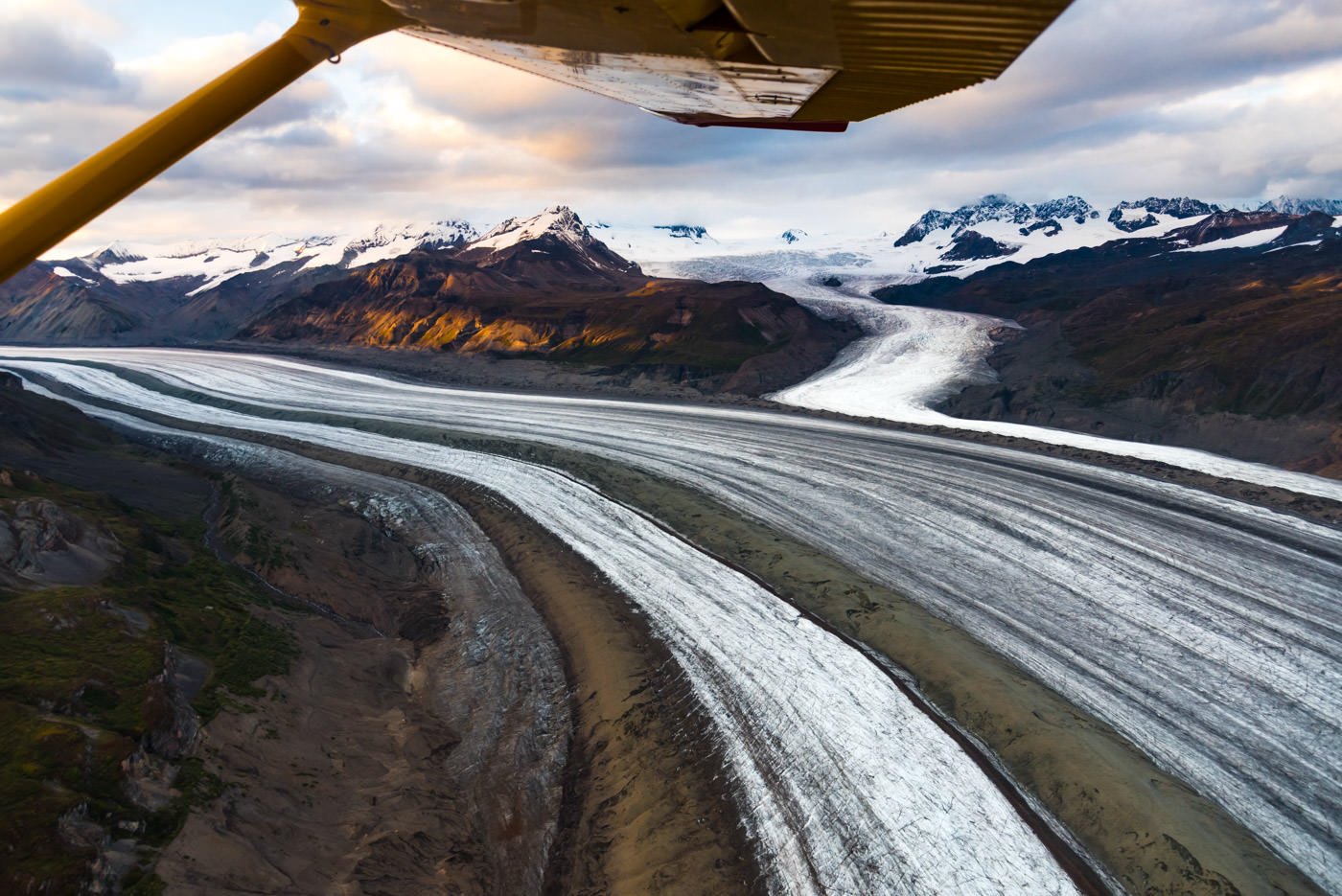
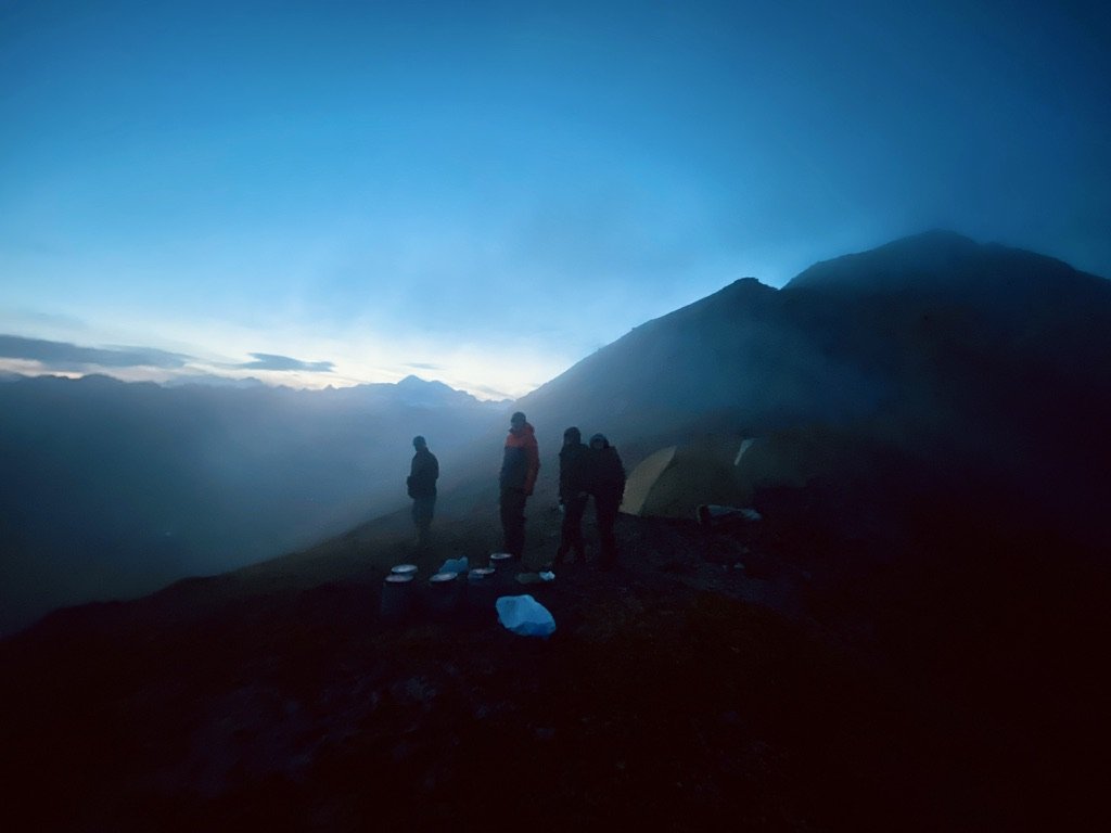
At 18, my boss sent me into the Wrangells for my first real guide assignment. Six days on the Goat Trail. At the time (and somewhat still today) it was the wildest terrain I’d ever experienced. Sixteen thousand foot deep valleys: the bottom 3k the Scottish Highlands, the middle 10k the Grand Canyon, the top 3k snow capped peaks pouring glaciers into the Grand Canyon.
The Wrangells — like all of Alaska — are changing fast as the climate warms up. But no doubt they’re still a sight to behold. The range isn’t so off the map anymore — but in a wilderness the size of Switzerland it’s really not that hard to get away from the crowds. There’s truly a lifetime of exploration here. I’ll just say it, the Goat Trail is cool. If you do a tiny bit of research about the Wrangells you’re sure to hear this trail named. But don’t be deceived — it’s not much of a trail. And besides, you’ll have more fun doing something lesser known and feeling the joy of creating your own route. Check out below and you’re sure to get some ideas.
This guide will cover everything you need to know to plan a successful backpacking trip in the Wrangell St. Elias National Park and Preserve. We’ll have helpful tips and tricks whether you want to go on a self-guided or professionally guided trip (or if you’re undecided). Read on to find out.

SEASON
The Wrangells have a bigger season than much of Alaska. That’s largely due to the fact that the main access town, McCarthy is t 1,401ft and the summit of the Wrangells (Mt. Blackburn) is 16,390 ft. Depending on the month you can chose an elevation band that makes sense.
As usual, June thru September is best.
June: you’ll want to be as low as possible to avoid snow.
July: Maybe still some snow in the higher parts. Great month
August: Being high helps avoid the bugs
September: If you’re not keen on wintery conditions, stay low. Likely rainy.
WRANGELL ST. ELIAS BACKPACKING ROUTES AND ITINERARIES.
Choose between North Side and South Side Access

South Side Access & Routes
In truth, the mountains are the mountains and you can get into them however you want to. But most trips into the Wrangells do start either from the town of McCarthy on the south side or Nabesna (and surroundings) on the North Side. You can drive to both of these locations from Anchorage. It’s a long 8ish hour drive to both, but pretty. The main logistical difference is that McCarthy is a vibrant town with hotels, restaurants and resources. Nabesna has one tiny lodge and is otherwise just a spot on a map where the road ends. You can get to McCarthy with public transportation. You’ll need a car to get to Nabesna.
From McCarthy or Nabesna you can hike in on foot or fly in in a bush plane. I’m not actually going to give many new routes that aren’t already published — it wouldn’t feel fair to the spirit of Alaska. But I will provide some insight on general access and the places people regularly get dropped off by plane. I’ll also say that if you want route ideas and aren’t afraid of a real adventure, take a look at the past Alaska Wilderness Classic trip reports. You’ll get a good idea of a route from Nabesna to McCarthy, albeit more or less requiring a packraft to complete. Or, just go on Gaia or Cal Topo and create your own route… that often yields the most memorable results. Remember, bush pilots in Alaska are wild folk and can often land almost anywhere… you don’t have to limit yourself to the landings they list online… if you have an idea, give them a call.

Getting to McCarthy / Kennecott
You’ve got a few options!
Drive: The simplest option. About 9 hours from Anchorage and you’ll be there. Note, most rental car companies won’t let you drive the 65 mile dirt McCarthy access rd. Either rent a car from one that does or plan on leaving your car in Chitna and taking the shuttle.
Drive and Fly: Drive from McCarthy to Chitna and take the short and awesome daily scheduled flight into McCarthy with Wrangell Mountain Air.
Fly Public: You can fly to McCarthy and or Fly and Drive with Copper River Air.
Fly Private: You can charter a flight from Anchorage to McCarthy with Reeve Air.
ON FOOT BACKPACKING ROUTES FROM MCCARTHY / KENNECOTT
Generally speaking, from McCarthy, consider heading East towards Nikolai Pass or North up and across the Root Glacier towards Glacier Gulch. The routes below are provided courtesy of the NPS.

Dixie Pass (pdf)
Accessed from the McCarthy Road.
Hike approximately 10 miles (one way) to Dixie Pass, an alpine pass with views of Mt. Blackburn. The first part of the route follows a trail, then off-trail travel is required for the last few miles to the pass. A high-clearance vehicle is recommended to access the trailhead, otherwise, plan to park at the McCarthy Road and walk 4 miles (one way) to the trailhead.
Nugget Creek Trail (pdf)
Accessed from the McCarthy Road.
An ORV trail leads 15 miles (one way) to the Nugget Creek Public Use Cabin and the Kuskulana Glacier. The cabin is very rustic and requires a reservation.
Erie Mine Trail (pdf)
Accessed from the Kennecott Townsite.
Hike on a primitive trail alongside the Root Glacier for 4 miles (one way). The trail ends where the cables from the Erie Mine descend from the hillside with the Stairway Icefall looming close by. Hikers looking for a longer trip can descend onto the Root Glacier and travel on the glacier another 2 miles to Erie Lake. The extension to Erie Lake requires glacier travel experience and equipment.
Donoho Basin (pdf)
Accessed from the Kennecott Townsite.
Donoho Basin is a peninsula of land between the Root Glacier and the Kennicott Glacier. The basin is dotted with lakes and there is a primitive trail through the basin. Bear resistent food storage boxes are available at selected locations. This route requires glacier travel experience and equipment.
PLANE ACCESSED BACKPACKING ROUTES
Flying into the Wrangells opens up a whole world of possibilities. In Alaska, the common expression is walk a week or fly an hour. In truth, it’s more like walk a month or fly an hour. Flights can be expensive, but are such a unique and beautiful experience in and of themselves that most people find them worth the cost. That being said, consider cutting cost by flying in and hiking out or vice versa.
Fly in / Hike Out
Nikolai Pass
Charter a flight to Nikolai Pass and hike back to McCarthy. The route is approximately 15 miles long. From Nikolai Pass, follow sheep trails to the ridge south of Nikolai Creek. The ridge leads down to McCarthy Creek. Once at McCarthy Creek, follow an overgrown old roadbed to the town of McCarthy. No trails to follow. Requires extensive trip-planning and advanced backcountry skills.
Fosse to Kennecott
Charter a flight to the Fosse airstrip on the far side of the Kennicott Glacier. Spend a few days exploring the area, then put on your crampons to cross the Kennicott Glacier. You can either follow the Kennicott Glacier all the way around the south end of Donoho Basin or go through Donoho Basin on an unmaintained trail. Requires extensive trip planning and advanced backcountry skills. Glacier travel is required. This route is approximately 14 miles long.
Lakina to Kennecott
Charter a flight to the Lakina airstrip in the center of the scenic Lakina River valley. You will hike upriver and ascend a pass into Hidden Creek. You will find beautiful alpine lakes at the top of the pass. As you travel down Hidden Creek, you will likely need to cross the creek a handful of times. At Hidden Lake, traverse around the north side of the lake and over a cliff band on a small trail. The views from the top of the cliffs overlook the Kennicott Glacier and the Hidden Lake. From there, make your way across the Kennicott Glacier and back to the Kennecott townsite. This route is approximately 25 miles long. This trip requires extensive trip planning, glacier travel, and advanced backcountry skills.
Fly In / Fly Out
Routes and descriptions provided courtesy of the NPS

The Goat Trail
The Goal Trail is a remote backcountry route that requires chartering an air taxi for a pick-up and drop-off. The route goes from Skolai Pass to Wolverine, and can be done in either direction. Despite this route being called the “Goat Trail”, there are no trails to follow and visitors must be prepared to navigate off-trail the entire route. Sections of the route have significant drop-offs and exposed cliffs and should only be done by those who are not afraid of heights. From Skolai Pass, the route goes over Chitistone Pass, down the upper Chitistone River, then cuts high through the cliffs on river right. Above Chitistone Falls, the route wraps up to the headwaters of Hasen Creek. For those looking for the most direct way to finish the route, another exposed section can be traversed from Hasen Creek to go directly to the Wolverine airstrip. Those looking for a longer trip can traverse from Hasen Creek over a pass into Doubtful Creek, then alongside an unnamed glacier into Grotto Creek and through the headwaters of Contact Gulch to arrive at the Wolverine airstrip. The route is approximately 25-30 miles long, depending on the route variation selected. This route requires extensive trip planning and advanced backcountry skills.
Solo Creek to Chisana
Hike from the historic town of Chisana to the Solo Creek airstrip chartering an air taxi for a pick-up and drop-off. There is an old horse trail for part of the route, but most of the route requires route-finding. Expect views of the glaciated University Range. The route has minor elevation gain/loss, especially in comparison to other, more arduous, routes in Wrangell-St. Elias. When leaving/arriving at Chisana, be advised that there is extensive private property. The route is approximately 26 miles long. This route requires extensive trip planning and advanced backcountry skills.
Iceberg to Bremner
This route is sometimes referred to as the “Seven Pass” route and requires chartering an air taxi for a pick-up and drop-off. This route can be completed from either Iceberg Lake to Bremner or in the other direction. You will need to be prepared for glacier crossings and have crampons. Expect expansive views of glaciers, alpine tundra walking, and one section of thick vegetation just above the Tana Lobe of the Bremner Glacier. It is approximately 30 miles long and visitors must be prepared to navigate off-trail the entire route. This route requires extensive trip planning and advanced backcountry skills.

Backcountry Drop Off Locations With Wrangell Mountain Air
Wrangell Mountain air is awesome. I’ll never forget that first trip at eighteen flying in with them. It really felt like I’d met a bunch of people straight from another century. The pilot flew past our lnading strip (i.e. random grassy hillside with a 3,000 ft drop to one side) a few times and when I asked him what he was doing he said he was trying to blow away the small cloud above the landing strip so he could see better. A wild bunch of super competent pilots. You’ll be in good hands.
Drop off locations and descriptions provided courtesy of Wrangell Mountain Air. Check their website for the latest prices.
Allie's Valley
The flight across the rugged Chugach mountains take you to this beautiful remote valley. Surrounded by hanging glaciers at the end of a long alpine valley, you will feel like the only persons on Earth. From here you can explore your valley, or cross a pass and check out the headwaters of another valley. The options are virtually endless.
USGS maps: Bering Glacier D6
Super cub strip.

Doubtful Creek
Located near the lake at the Nizina Glacier terminus, this location offers a variety of hiking terrain and expansive views dominated by nearby Nizina and Chimney Mountains. Follow the river bank upstream, along the glacier margin where blue ice is exposed by calving, seek out waterfall fed rock pools off of Moonshine Creek or ascend Doubtful Creek into the higher country.
USGS maps: McCarthy C4
Fan Glacier
Located to the south of McCarthy about 50 miles, the Fan Glacier area offers great base camping and day hiking. Surrounded by high peaks, with glaciers in every direction the views are stunning. Although there is some low brush on the lower slopes the ridge to the north is accessible from the landing area. Hiking above the lower brush band is in alpine tundra and amongst small ponds that stud the ridge like aqua blue jewels. From here you will be able to see 100 miles on a clear day. Just off of the airstrip are some beautiful small lakes which make a wonderful camping spot. There are long and beautiful sand bars to stroll if a hike up the mountain is not your thing.
USGS maps: Bering Glacier D1, D7, and D8.
The Fosse
Tucked neatly between the Kennicott Glacier’s lateral moraine and the base of the adjacent mountain, this landing strip offers a variety of amazing glacier views and exploring options. Hike along the flat fosse terrain, climb the green alpine slopes above or walk along the Kennicott Glacier.
USGS maps: C6

Horsfeld
The flight out of McCarthy will take you through beautiful Skolai Pass and down the White River before heading west into the Nutzotin Mountains. You get to see a lot of the park on this flight. There are opportunities for day trips in all directions out of Horsfeld or you could do a loop trip. Lakes and valleys to the north invite exploration or make the crossing of Beaver Creek and explore the hills and mountains to the south. The variety of terrain ensures that there is something interesting and challenging for hikers of all abilities. This part of the park is seldom visited.
USGS maps: McCarthy D1, D2 and Nabesna A1, A2
Iceberg Lake
Near wide views of massive Bagley Icefield, this landing strip offers a variety of hiking terrain. Enjoy easy hiking along the lake; access the nearby white ice of Tana Glacier or climb steep slopes to higher elevations. Glaciers spilling from hanging valleys, the roaring creek and calving ice all accompany the stunning solitude.
USGS maps: Bering Glacier C6, D6
Nikolai Pass
In the alpine country of Nikolai Pass, look to Mt. Blackburn (16,390’) in one direction, the snowy University Range (16,421’) in the other, and the glacial waters of Nizina River 2400’ below. Hike along rolling slopes toward the base of Sourdough peak, or explore nearby remains of old Nikolai Mine. Great photo opportunities.
USGS maps: McCarthy B5
Super cub strip.
Nizina Glacier
Land at the end of glacier lake filled with icebergs from nearby Nizina Glacier. The views from the lakeshore are outstanding and there is a public use cabin tucked into the wood about a half a mile from the airstrip. This area offers casual hikes along the lakeshore and gravel bars along the Nizina River as well as routes up Nizina Mountain to alpine areas above treeline. This spot has it all; glaciers, rivers, mountains and a snug cabin in a pretty setting.
USGS maps: McCarthy C4, C5
Ross Green Lake / Granite Creek
Located at the base of jagged Thompson Ridge, innumerable surrounding peaks compose an exciting alpine landscape. From the landing area on a sand bar near Ross Green Lake, explore along Granite Creek or climb to higher elevations. See long open views of Tana Glacer to the west, stretching from the giant Bagley Icefield, which lies just 5 air miles away to the south.
USGS maps: Bering Glacier C5, D4, and D5

Skolai Pass
From the landing strip at 4500’, behold Russell Glacier spilling rocky ice into the gravely expanse of the White River bar. Exploring the alpine terrain, views of Hole in the Wall Glacier, icy University Range (16,421’) and grazing caribou call you in all directions.
USGS maps: McCarthy C3
Steamboat Hills
This is a delightful area for base camping, especially for families. You will be surrounded by a magical, almost pastoral landscape of rolling hills sprinkled with tiny lakes that sparkle like freshly cut emeralds nestled among velvety green pillows. At the periphery of the central hill country is a ragged ridge line of rugged crags and peaks that form a dramatic backdrop to the gentler terrain of our route. One of the highlights of this area is the opportunity for viewing the many Dall sheep that inhabit the area. The wide open terrain makes them easy to spot from afar. But bring your telephoto lens if you want to get up close and personal with these elusive animals.
No minimum passengers. Super cub strip.
USGS maps: McCarthy A7, A8, B7, B8
Tebay Lakes
Land in open meadows at the end of a lake-filled valley. Encompassed by hanging glaciers and jagged mountains, enjoy rainbow trout fishing in the blue alpine waters. You can day hike two miles to a large waterfall or pick your way up the rocky, green slopes to higher elevations.
USGS maps: Valdez A1, A2

Wolverine Mountain
Located on an alpine bench above Chitistone Canyon, this 5000’ home for Dall sheep and mountain goats, is an excellent spot for day hiking and backpacking. View the snowy ampitheater of the University Range from nearby higher terrain.
USGS maps: McCarthy C4
Wrangell Plateau
Take a hike along the lower slopes of Mt. Wrangell. The broad, trundle plateau gives you unobstructed views and easy access to the icy Western side of this 13,887’ peak. On a clear, windless day you may catch a glimpse of the steam plume rising lazily from this active volcano. Hiking is easy to moderate on alpine tundra, and good camping spots can be had near small lakes and numerous clear streams. For the alert backcountry traveler, this location offers good opportunities to see caribou, dall sheep, wolves and bears.
USGS maps: Valdez D1

NORTH SIDE ACCESS ROUTES
The North Side is a bit harder to get to and definitely has a more remote feel. You probably won’t see a soul and you’ll hear less bush planes to boot. You can hike in, fly in, or do a combo pretty easily. The terrain over here has a distinctly different feel from the South side — more wide open feeling.
Getting to Nabesna
Really your option here is to drive. Or hitchhike. Simple. Unlike McCarthy, there are no rental car restrictions on driving the Nabesna road. Somewhat surprisingly, it’s about the same distance from Anchorage to go to Nabesna as it is to go to McCarthy. But unlike McCarthy, there’s almost no tourist infrastructure in Nabesna other than the quaint Devils Mountain Lodge. Make sure you leave Anchorage with everything you need for your trip.
ON FOOT BACKPACKING ROUTES FROM NABESNA
In general, head South up the Jacksina river onto the Jacksina Plateau or onto the Jarvis plateau. There’s a good bit of gnarled bushwhacking, but once up on the plateau you’ll have epic views of the big mountains.
Route descriptions below courtesy of the National Park Service.
Soda Lake Trail (pdf)
Accessed from the Nabesna Road.
Hike on an ORV trail that leads 15 miles to a blue lake. You will start at the Lost Creek Trailhead, then after 3 miles turn onto the Platinum Creek Trail, which leads to Soda Lake. Both the Lost Creek and Platinum Creek ORV trails cross the creek multiple times and require minor route-finding to stay on the trail. Prepare to have wet feet from crossing the creek multiple times.
Trail Creek-Lost Creek Loop (pdf)
Accessed from the Nabesna Road.
Hike up the Trail Creek ORV trail until it ends, then navigate your own way up the creek a bit further and over a pass. On the other side of the pass, you’ll descend into Lost Creek. You’ll connect with the Lost Creek ORV trail, then follow it back to the road. Both the Trail Creek and Lost Creek ORV trails cross the creeks many times, so be prepared to have wet feet. The route is 24 miles long and can be completed in either direction.
PLANE ACCESSED ROUTES FROM NABESNA
If you can afford the flights, you can pop yourself out above all the bushwhacking into some of the easiest walking in the Wrangells. Otherwise, be prepared for the real Alaska bushwhack to get up high above the Alder. Fly in with Kirk from Devils Mountain Lodge.

Fly In / Hike Out
Jacksina to Nabesna
Fly in to the Jarvis or Jacksina Plateau and hike back out to Nabesna. More dramatic if you reverse this, but more uphill too.
Fly in / Fly Out
Horsfeld to Solo Creek
This route is a remote backcountry route that requires chartering an air taxi for both a drop-off and pick-up. The route goes from Horsfeld to Solo Creek, and can be completed in either direction. From Horsfeld, you will hike up an unnamed valley and cross into Ophir Creek. From Ophir Creek, ascend an unnamed valley into Shotgold Creek, then on into the North Fork of the White River, then follow ridges to the Solo Creek airstrip. Expect expansive views of rolling hills with glaciated peaks in the distance. The route is approximately 35 miles long and visitors must be prepared to navigate off-trail the entire route. This route requires extensive trip planning and advanced backcountry skills.
Sanford Uplands
Hike from the Copper Glacier to the Sanford Glacier airstrip, requires chartering an air taxi for both a drop-off and pick-up. You can complete the entire route, or if you’re looking for a shorter trip, you can just do a segment of this route since there are multiple airstrips along the way. The full route is approximately 42 miles long. Most route variations entail glacier and glacial moraine crossings. Expect up-close views of Mt. Sanford as you travel along rolling tundra foothills of the glaciated mountains. Be prepared to navigate off-trail the entire route.
TO GO ON A GUIDED OR UNGUIDED BACKPACKING TRIP IN ALASKA?
Whether to go on a guided backpacking trip in Alaska or run the trip yourself comes down to a few important considerations.
Skill: Do you and the people in your group have the skills and know-how to safely pull off the trip you want to go on? In addition to all the basic backpacking skills, do you
Know how to competently navigate off trail without getting lost, even in severe weather or complete multi-day whiteout conditions?
How to switch routes last minute and navigate without any prior route preparation.
Know how to safely navigate grizzly and black bear country?
Know how to manage complex wilderness medicine and rescue scenarios when rescue may be many days away?
Know how to cross (or avoid) swift and deep rivers safely?
Know how to keep everyone warm and non-hypothermic even if it rains every day of your trip without ever getting a chance to dry things out or start a fire?
Logistics: Do you have the desire to put all the logistics together yourself. Would that be fun for you?
Planes, permits, trains, gear, food, routes, emergency plans, finding the best areas with the nicest travel and most beautiful scenery?
Would you enjoy joining a group and building group culture and cohesion?
This is always a bit of a curveball. On a guided trip you’ll be with people you’ve never met before. That can be incredible and sometimes it can be challenging. With rare exception, people come out of our trips saying the connections and friendships they forged to other people in the group were one of the standout highlights.
On the other hand, curating your own group can be awesome — you can share those memories with loved ones for the rest of your lives.
If choosing a guided group, definitely check how big the groups are. This can make a big difference. At Indigo Alpine Guides, we keep our groups limited to seven people. We find this provides a way better feel than trips with 10 or more people.
GEAR SUGGESTIONS FOR BACKPACKING THE WRANGELLS
I’m not going to go through a full packing list, just some helpful suggestions. Of course, use your own judgement and experience.
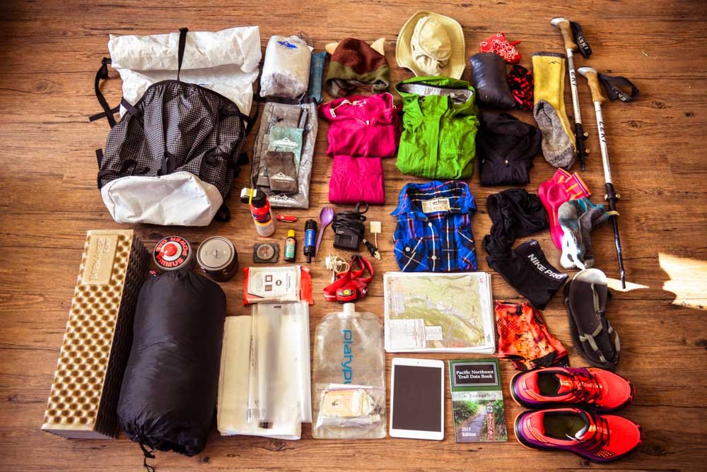
Avoid down clothes. No cotton clothes. No down sleeping bags. Honestly, sometimes you just get soaked to the bone in Alaska — having synthetic clothing and sleeping bag (which keep you warm even when wet) can add a huge margin of safety and comfort.
Super strong tents with 6ft of p cord at each corner so you can use rocks instead of stakes for anchors (good for strong winds.
Ursack. Honestly, bear cans suck. If you can afford an Ursack it’s a worthwhile investment. Otherwise you can use your own bear can or rent them from the park for free.
Non-GoreTex Footwear. You will get your feet wet on your Denali backpacking route. Gore-Tex just means that your shoes will take longer to dry when the sun does come out. A good pair of camp shoes is also a big plus! Crocs without holes in them are my go to.
Gaia! I personally use Gaia for all my backcountry travel. But whatever you use, it’s good to not be reliant on paper maps. On one trip I did almost 10 years ago, it was so windy and rainy and snowy that our map literally disintegrated even with our best intentions to keep it protected in plastic.
No backpack rain covers. They rip off while bushwhacking. Instead, line your backpack with a thick compactor bag. Just twist and tuck the top of the bag to create a water tight seal.
Make sure you check with any planes or public transport about carrying fuel, bear spray, or firearms. You may need to use a specific kind of fuel or buy directly from them.
You do not need a gun to travel in Alaska! Bear spray is absolutely adequate. Practice good conservative bear awareness and you will never need bearspray or a gun.
An InReach. This is a good idea no matter what. But if you’re relying on a plane to pick you up it’s essential. Make sure you get a textable number from your pilot before you leave.
Lightweight crampons… if you’re route involves dry glacier. Sure, you can often get away without them… but I find they just make it feel more comfortable.
RESCUE INSURANCE

We’re going to write a whole article about rescue insurance so keep an eye out for that. But basically, Alaska is remote. Any rescue could cost you tens of thousands of dollars. Most travel insurance companies won’t actually cover remote rescue. When you buy a policy, make sure you confirm that they actually cover the adventure you’re going on. On personal trips, I have a pretty high risk tolerance, but I still choose to have rescue insurance year round. I highly recommend having it. But I even more highly recommend you don’t let the modern (relative) ease of rescue influence your wilderness risk tolerance. Just because you have an InReach with an insurance policy, doesn’t mean you ever want to have to use it.
2 options I recommend:
If you have an InReach, purchase their SAR 100 plan. This is cost effective and will smoothly integrate with any rescues initiated from your InReach. This plan only covers the one person who owns the device. You will need to purchase seperate policies for each person on your trip if you want them to be covered.
Global Rescue. This company is the gold standard for wilderness rescue and the only insurance I trust for my remote trips in places like Alaska.
FINAL THOUGHTS
I hope you’ve found this helpful! Of course, if you want to go on a guided backpacking trip reach out. Or if you’re planning a personal trip and have some questions, feel free to email or text me. I also offer paid trip consultations for folks who have a lot of questions and / or want help creating a route.
If you go out on a trip and this guide helped out, tell me about it in the comments! Always keen to hear people’s stories!